Rock Road Wildlife Corridor
Building Climate Change Resilience for at-risk species in an agricultural landscape on the highlands of the southern Atherton Tablelands
Since 2010, TKMG has focussed its efforts on habitat restoration in the uplands of the Southern Atherton Tablelands. This is consistent with the group’s Community Action Plan for the Conservation of Lumholtz’s Tree-kangaroo.
Rock Road Corridor
This corridor, which links the Herberton Range/Mt Hypipamee National Parks section of the Wet Tropics World Heritage Area to a c1000 hectare remnant outlier, has been identified as a priority for restoration in the Wet Tropics Conservation Strategy, Sustaining the Wet Tropics (the Regional NRM Plan) and the State Government’s 2030 Regional Plan. This outlier of endangered upland rainforest is entirely in private hands, and is now largely protected under Nature Refuge Agreements with the Queensland Government. While the threats of land clearing and logging have eased, climate change and fragmentation remain as the greatest threats to its habitat values.
Detailed modelling conducted by James Cook University highlighted areas in most need of protection and restoration in the face of climate change. This remnant is part of the upland forests identified by scientists as some of the most important cool, wet refuge areas in Australia for animals and plants which are vulnerable to climate change. These cool refugia make up 25% of Wet Tropics rainforests and contain 45% of its endemic species. They provide habitat for endemic species such as Lumholtz’s tree-kangaroos, lemuroid & green ringtail possums, golden & tooth-billed bowerbirds, Victoria’s riflebirds, southern cassowaries and several endangered frog species.
Background
Prior to 2005 most of the land parcels in the outlier had been subject to, and remained available for private forestry. Then something remarkable began happening. One by one more than half the properties have changed hands; purchased by people who value the forest more for its biodiversity values than its utility. Many of these properties are now protected under the Queensland Government’s Nature Refuge covenant program. Several of the new owners went further and started revegetating their now disused pastures.
But there remained a problem. The forest sat ecologically disconnected from the nearby Herberton Range National Park & Mount Hypipamee NP sections of the WTWHA, separated by expanses of pasture.
In 2010 the Wet Tropics Management Authority joined with TKMG and other local community to deliver a multi-facetted project (funded through the Commonwealth’s Caring For Our Country program) addressing connectivity barriers in the uplands, including Rock Road. The initiative focussed the community’s attention to this area. 2 of the existing Rock Road landowners came on board and allowed about 5 hectares of pasture to be revegetated, starting the process of re-establishing landscape connectivity. These landowners and their neighbours along the corridor were reluctant to allow any further planting; thwarting the community’s attempt to complete the corridor.
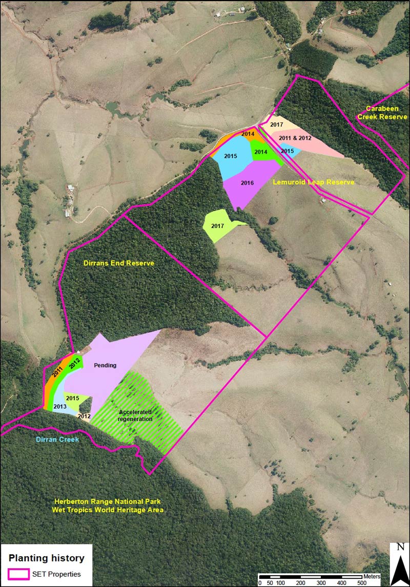
In 2010 the South Endeavour Trust (an independent, not for profit private conservation land trust) had purchased 2 of the key properties in the outlier, at the northern end of the corridor. After persistent negotiations spanning 2013-15, SET was able to purchase all 3 properties along Rock Road, removing those last barriers.
This is truly a landmark in the history of ecological restoration in the Wet Tropics region. In 2012 the WTMA led “Making Connections” project (underpinned by JCU’s modelling) won the community category of the Australian Climate Adaptation Champions Awards, presented by the National Climate Change Adaptation Research Facility.
TKMG’s contribution to this project has been by way of sourcing and securing grants to fund restoration activities, including the following:-
Timeframe: 2010 - 2012
Rock Road Wildlife Corridor: Building Climate Change Resilience for at-risk species in an agricultural landscape on the highlands of the southern Atherton Tablelands
Partners: TREAT, Malanda Landcare, Tablelands Regional Council Community Revegetation Unit, School for Field Studies, Conservation Volunteers Australia, Wet Tropics Management Authority, Queensland Parks and Wildlife Service.
Results: Prepared and planted a 1.5 hectare pasture site with 3100 local native trees. Erected 500 metres of exclusion fencing. Maintained site to control weeds after planting. Removed old fencing that separated existing vegetation from the planting site. Successfully negotiated with Wet Tropics Management Authority (WTMA) to assume responsibility of planting and expand the planting after the life of this project. 2012 saw the planting expanded to almost 3.5 hectares with funding supplied by a CfOC grant via WTMA.
Timeframe: 2015 - 2017
Completion of the Rock Road Wildlife Corridor
Partners: South Endeavour Trust, TREAT, Tablelands Regional Council Community Revegetation Unit, School for Field Studies, Conservation Volunteers Australia, Queensland Parks and Wildlife Service
Project Scope: This ambitious project will see over 20,000 trees planted on 7 hectares of (now) disused pasture. Co-funded by the South Endeavour Trust, the project will utilise ‘best-practice’ rainforest restoration techniques to ensure that the plantings become self-sustaining in the shortest possible timeframe. This includes exclusion fencing, installation of water tanks as insurance against dry weather, and regular weed control until ‘site capture’ is achieved.


